| Utah (Northeast and East- 5 Hikes) |
|
Fisher Towers Trail – Moab, UT Devil’s Garden - Arches National Park, Utah (Side Trip: Cove of Caves/Double Arch) Upheaval Dome Overlook Trail - Canyonland National Park, Utah (Side Trip: Mesa Arch) Grand View Point Trail - Canyonland National Park, Utah Peek-a-boo Trail - Canyonland Needles District, Utah (Side Trip: Needle’s Overlook) Accomodation Tips: instead of staying at a chain hotel, stay at a local bed & breakfast such as the one ran by Ann & Vic off Desert Hill Drive near Moab, Utah. We like to stay at B&B if possible since 1) this pumps money into the local economy, and 2) to obtain invaluable local knowledge not found on the web or books.
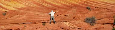
Fisher Towers Trail – Moab, UT Climbing the Fisher Towers is for experts only… but there is no stopping for taking a hike beneath these nature’s skyscrapers. There are about a dozen of these brick-red monoliths grouped together like a petrified city. The towers can only be described as spectacular and beg to be climbed. Mary and I are only novice climbers so tackling this dream climb is out of question. We took the easy hike instead. The Towers are located between Moab and Cisco, Utah. To get there, drive north from Moab along HWY 128, or south from Cisco on HWY 128 to the Fisher Towers Road, located between mile markers 21 and 22. The road dead-ends at the trailhead past the campground. From the trailhead the trail first drops down to cross a small dry wash, and then winds its way around the Towers (on your left). We somehow got lost and followed too much to the left and ended up on taking the climber’s route (as we later found out). The trails started out as a easy hiking trail but soon we started to scramble up and down little gulleys and large rocks; we found ourselves surrounded by towers to our front instead of on our side. I told Mary I am utterly surprised at how challenging this hike is turning out, and wondered if this will continue for the next 4 miles. Basically, we were hiking/scrambling/circling directly underneath the towers. At one point, we found ourselves beneath a ledge with a steep drop-off to our right; I kept wondered how in the world can this trail be rated easy – I told Mary we must be getting old. After about 30 mins, after passing a round rock that sits precariously at one end of a ledge, we somehow squeeze through our way through 2 large boulders and got back on the main trail, only then we realized we took the wrong trail. An elderly couple started about 30 mins behind us suddenly appeared right behind us. They must think we were really slow. Therefore, you can't get lost since the all trails encircle the towers, and will eventually lead you back to the main trail. Tthe main trail should be well maintained and graded. For the first mile or so the main trail should proceed in a southerly direction along the tower bases, you should not stray too far or get to close to the towers. We encountered a number of scrambling routes that runs directly beneath the larger towers, stood below the towers with my head tilted back sent an exhilarating chill through my body. I can only imaging the feeling of dangling on the tip of the tower, and then the tip gave away under my weight (just kidding). The largest of the towers (Titan) is at about 1.5 miles from the trailhead. After passing the Titan the path veers southwest onto a ridge where we were rewarded with a spectacular view of the Towers and its desert surroundings. We even saw a tiny “peek-a-boo” formation along the trail. The trail ends at an outlook. The morning sun gave away to a snow shower by the time we arrived at the outlook. As the snow shower intensified, we started to jog to get back to our car before the trail becomes a slick muddy mess. On our way back, we noticed the ledge we had traversed earlier was about 2 stories above the main trail. Needless to say, we got back to the car very quickly without having to hike in all fours again. Tips: no special equipment is needed; bring rain jackets/pants since the weather can change quickly around the towers. Distance: ~4.5 mile roundtrip Rating: 9 out of 10 Devil’s Garden - Arches National Park, Utah The Devils Garden Trail along with the primitive loop trail, is probably the best hike in the park. One look on the park map you will notice the large concentration of arches in this area. The trailhead is situation at the northern end of the park, arrive early to avoid crowds. The loop took us to to Tunnel Arch, Pine Tree Arch, Landscape Arch, Wall Arch, Partition Arch, Navajo Arch, Black Arch, Double O Arch, Dark Angel monolith, Private Arch and a trip through Fin Canyon. The trail was fairly level for the sections closer to the trailhead. There were Pine Tree & Tunnel Arch off to a side trail (I believe it’s called Spur Trail) only a short distance from the trailhead. The famous Landscape Arch was only about a mile from the trailhead; it’s a long slender arch that stretches few hundred feet across. At least half the visitors stops at this point, but from here and up, the scenery improves by leaps and bounds. Leaving the sandy wash behind, the route became steeper and primitive, there were some scrambling involved around the slick rocks. About a quarter mile down we encountered a fork leading to the Partition Arch. The Partition Arch offered a different point of view since you are peering through the arch into the opens below. After having lunch, we returned to the main trail and continue up to the Double O Arch. The Double O also offered a nice view from the higher advantage points. Tips: no special equipment is needed for this hike. A little scrambling is required at some sections furthest away from the trailhead so gloves could be useful. Try not to use trekking poles without protected tips since the ends can damage the already fragile sandstones. Ask the ranger which Arch can be climbed before any attempts to stand above the arches. Distance: ~7 miles round trip if all trials are explored Side Trip: Cove of Caves/Double Arch – on your way out from the Devil’s Garden, stop by the Cove of Caves, it’s a short stroll to the cove, and a few brave souls manage to climb up to the opening of the arch. Be warned, it’s a long way down (one hundred+ feet) from the opening of the arch to the valley floor. The view is spectacular. Just remember to keep your mouth closed or you’ll be swallowing air and sand. Please tread lightly when visiting (i.e., do not dig the ends of your trekking poles into the sandstone). Upheaval Dome Overlook Trail - Canyonland National Park, Utah The goal of the hike is to get to the overlook, hike onto the dome and go as high up as possible. If you are lucky, you may able to spot the ancient granary storage areas directly underneath the top of the dome. To me, the domes looked like giant heaps of manure. The hike starts off at the Upheaval Dome parking area. We headed straight out toward the domes. After an uneventful stroll passing the 1st dome on our left, we climbed onto the second dome. We followed the cairns and climbed as far as we could until the trail abruptly ends toward the upper stretch of the second dome, any additional advancement calls for some precarious climbing and a slip here can be a long way down. We weren’t prepared to tackle such dangerous section of the hike so we back tracked. Tips: no special equipment is needed other than adequate water. Length (round-trip): ~1.5 mi Side Trip: Mesa Arch – it’s a short stroll to the Arch, this is one place where you can jam an arch, desert floor and snow capped Mesa Mountains of Colorado into one photo. Grand View Point Trail - Canyonland National Park, Utah If you only have half a day at Canyonland Island In the Sky district, Grand View Point Trail is perhaps THE trail you must hike. It only takes about an hour or two but the views are magnificent. The trail starts off at the Grand View Point and is easy to follow. The entire trail runs around the out edge of the ‘Island’, an easy walk straight in and out. The vista through the entire hike is spectacular. The trail ends at the end of the “Island in the Sky” Mesa and offers a 270 degree Panoramic View. Tips: no special equipment is needed other than a bottle of water. Sky Mesa is an awesome place for lunch. Be careful not to get too close to the edge. Mary and I stood on a slab (a little wobbly) and saw an elderly couple took our picture then yelled to us “there is nothing underneath you”… Yikes! Total Distance: ~1 mile Peek-a-boo Trail (Real Peek-A-Boo) - Canyonland Needles District, Utah Getting to the needles section of Canyonland National Park is a treat by itself. The drive was spectacular. We visited in April and we were greeted by a snow storm, sun over blackened clouds, and incredible views of the red rock canyons layered one after another. The trailhead to the Peek-a-boo trail is next to the Squaw Flat Campground, there is a strip of parking lot on your left before the terminus of the campground road. The hike proves to be a long one but it was never boring. We started the hike with an easy stroll through a grassy fields and emerged onto the tops of small hills. The terrain was mostly ups and downs consisting of a series of hill hoping with an eventual goal of climbing to the top of a canyon wall. It rained the night before so we were greeted with patches of waterholes dotted on top of the hills – this was a nice surprise and a good photo op. We encountered numerous sections of the ‘trail’ without a definite trail other than a walk on the red rocks themselves, but overall the trail was easy to follow thank to the cairns. More than once I remembered doing some scrambling up a crack, swallowed a face-full of wind and confronted by a giant cliffs towering next to us. There was more than one place where we needed all fours to navigate, but this was a part of the fun! We encountered very few people on the trail other than three girls wearing backpacks twice their size. On our way back they ‘chased us’, I kept telling Mary I was surprised at how quick they gained ground on us. Only after catching up to us we realized all they wanted is to have us take their group picture. I also remembered climbing down a steel ladder and got down into a sandy wash and thought we were close... but by the reading on the GPS soon found out we were only half way there. Eventually we lost count of how many mountain or hills we had circumvented. But it was never boring since the scenery kept changing. A sense of awesomeness, desolateness and peacefulness accompanied us through the entire hike – it was a feeling difficult to describe and can only be experienced first hand. After skirting on the left side of a mountain for a while, hopping over a few potential dangerous (especially if wet) sections of trail with drop offs to our left hand side, we arrived at the real Peek-a-boo. It’s a large hole/notch in the middle of the top section of a red rock slab that separates one side of the mountain from the other. Crossing the Peek-a-boo we stayed to the right, skirted beneath the hill top and encountered more (smaller) Peek-A-Boo, coincidentally we were also greeted with a gale force wind. During our initial descent; the wind was so strong that Mary had to drop onto one knee for a few seconds before regaining her balance. We stopped short of the other campground at the trail’s end and retraced our steps back to the trailhead. Tips: bring enough water and a lightweight rain jacket (block wind if needed). Be prepared to hike a few sections where caution is needed. It’s not a long way down but a slip can be a real concern in this part of the country. It’s hours away from any help. We carried a person GPS Beacon for emergency evac. If there is someone in the party who is afraid of the heights and do not like climb over bounders, bring a section of rope. Distance ~8 miles roundtrip Side Trip: Needle’s Overlook - The overlook is situated 10 miles north of Canyonland Needles NP entrance on Hwy 191, it’s a 22 miles from Hwy 191 on paved road. Few tourists know about the overlook. Its vista is stunning during sunrise/sunset.
|