| Oklohoma (3 areas) |
|
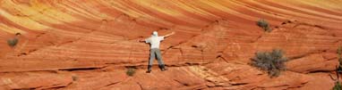
Elk Mountain Trail (and Charon’s Garden Trail) - Wichita Mountains Wildlife Refuge – OK Who says Oklahoma is flat… just minutes from Lawton, OK is a group of mountains that stands tall. We have visited these mountains multiple times and still find something new on each trip. For starters, there are 2 trails we liked the most – Elk Mountain & Charon’s Garden. Getting to the trailhead is easy; just follow the sign for Wichita Mountains Wildlife Refuge as your approach Lawton. From I-44 take Highway 49 (exit 45), go west 10 miles to the refuge entrance. If coming from HWY 62, take HWY 115 (Cache exit) north to the Refuge Gate. The refuge has a generous visitor’s center and offers help on climbing, camping and hiking. The 2 trails share the same parking lot, traveling West on Hwy 49 and watch for the sign for the trails. It’s the last left turn before exiting the park. From the parking lot, cross the footbridge by the parking lot will take you up the mountain to the Elk Mountain summit, take a stroll pass the restrooms will take you to the trailhead for Charon’s Garden. If you are a hardy hiker, you can do 2 trails in 1 day. I recommend split the trails between 2 days to allow ample time to explore each area. Elk Mountain Trial is a steep trail that leads you to the summit of the Elk Mountain; this trail is short but can be strenuous. The view on top is very good. The summit gives away to a 270 degree view of the surroundings. We found it especially interesting to explore around the summit and hop around the boulders. It’s truly a refuge, a place to relax and enjoy the wild. Speaking of wild, Charon’s Garden surprised us to some degree. We hiked from both ends of the trail, and have sought after numerous non-technical class 2-3 climbs in the area. The trail has a midsection that is littered with rocks 2-3 times as tall as a normal adult. Finding ways to navigate around the rocks was sometimes challenging (and can be dangerous) but fun; proper risk management is mandatory - having the right equipment, reasonable risk tolerence and adequate support (don't go alone) are critical. The northern end of the trail starts off at the same trailhead as the Elk Mountain Trail, the southern end of the trail starts off at a different parking lot and offered more solitude. When we hiked the southern section for the 1st time, we got lost. We bush wacked our way through a canyon floor off to the right of the main trail and waded through grass chest tall not knowing if we had disturbed any rattlers that is infamous for this region. Eventually we wound up doing some class 3-4 scrambling up a hilltop before bush wacking our way back down the valley. Our hike inadvertently turned out to be a bouldering adventure. BTW: we have ventured out to Charon's Garden multiple times. Crab Eyes is one of the best kept secret in the garden. It is a well-kept climbing/bouldering stop with minimal signs of usage. Overall, people visiting this wilderness area appears to be true nature lovers.. not once have we seen any litter along the trail or any initials carved into the rocks. We are truly happy to see Charon's Garden remain wild... and respected by the locals. If top roping, please wrap a blanket on any surface where there is a possibility of abrasion from the ropes. Nature's marvel is truly breathtaking yet extremely fragile. If you have indoor climbed before and not afraid of heights, there is a minimal impact non-technical route to the top of Crab Eyes from the back (but be warned, even on this route there are some Class 4 exposures where a slip can be a serious concern; wear climbing shoes if possible). TIPS: Elk Mountain Trail – hike in cool weather. It can be very windy on top. Charon’s Garden – if starting from the southern end of the trail, not far from the trailhead you will see a fork (Y shape), the trail on the left will take you to the main trail and the rock garden. Take the trail on your right (like we did) and you are on your own! If hiking off the main trail, wear gaiters may help with rattlers’ bites. Distance: Elk Mountain: 1.1 Miles, Charon’s Garden: 2.4 Miles Side Trip: take a drive to Mt. Scott. There is a 360 degree view on the summit. Also visit the ground hogs; there is a dirt road lined with ground hog 'mounds'; the end of the road has a beautiful field of tall-grass.
Quartz Mountain Quartz Mountain is less than an hour from Wichita Wildlife Refuge (WWLR) and is a hidden gem for rock climbing minus the extreme heights. The ‘mountain range’ is more spread out than that of the WWLR and as one of our favorites; the tall grass on the trail along with little evidence of trash are signs of low human impact. There is a designated Climbing area dedicated to class 3-5 climbing, a true adult playground. Getting to the climbing area is easy, when entering the Quartz Mountain area, at the Y fork take the road on the left. Taking road on the right will take you into the center of the park/lake area/park office/campgrounds. From the trailhead beneath the granite slab, the trail is in one direction to the West (go right). There are numerous entry points for climbing with some Class 3-4 scrambling available taking you all way to the top. As always, take generous precautions, choose your route well and watch for rattlesnakes. An over zealous urge to climb up the granite without picking out a good route may cause you a literal headache when coming down. As a rule of thumb, it’s always easier to go up than coming down & most accidents happen while coming down. Wear climbing shoes & helmet if possible and get ready for some toe bruising; the angle of the granite slabs can be deceiving.
Beavers Bend State Park - OK Beavers Bend State Park (a.k.a. Beavers Bend Resort Park) is one of the most popular parks in Southern Oklahoma. The place boasts some of the finest trout fishing and paddling in the region, it also has a wide variety of accommodations including campgrounds near the river. The park’s entrance is located seven miles north of Broken Bow on US-259A. During our visit, we attempted the 6 mile long Skyline Trail (trailhead to trailhead). It is suppose to be a loop hike that takes you to the top of the bluffs and ridgelines. Unfortunately, we were told that logging (of the forests) has caused a section of the trail to be closed. We end up hiking up to Bee Creek and turned back. If we had the opportunity to hike this trail again, we would’ve turned around when we hit the bluff top; the rest of the hike prove to be strenuous with lots of ups and downs in the forest with few views. Tip: Call ahead and ask for trail closures; it was unfortuate that logging had encroached upon this piece of wilderness. Let's hope the impact is minimal. Distance: ~5 miles
|