| California (Yosemite, Death Valley and Side Trips) |
|
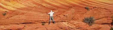
Upper Yosemite Fall Trail – Yosemite National Park, CA Taft Point – Yosemite National Park, CA Wildrose Peak - Death Valley National Park, CA Upper Yosemite Fall Trail – Yosemite National Park, CA This hike was a surprise - we didn't expect the ruggedness of the trail, better than expected scenery and the fact that it’s a ‘summit’ hike rather than a stroll underneath a waterfall. We started off with an intention to turnaround at a pre-establish time, as we went up further, we realized we had plenty of time to spare so we continued... As we got closer to the top, we were greeted with giant pine trees each with its trunks slathered with bright green moss. We were never above tree-lines since junipers up here extend all the way up to the summits. When we arrived at the top, we were surprised by the number of people made it to the top; there were quite a few rock climbers perched precariously on the rocky outcrops. We hiked down a side trail off to the left from the summit to the top of the waterfall; there was not much to see since the water flow was down to a trickle. However, the scenery at the summit was spectacular – you have the Yosemite Valley on both sides and the view of Half Dome in the distance. We had lunch, meditated on the rocks for a while and quickly descended. Tip: Bring adequate water and food (this trail is a calorie burner). Sturdy shoes/boots is recommended. Don’t give up on this trail when you start to think ‘when will this trail end’? Establish turnaround time and bring high powered headlights if expecting a late descent. Total Distance: ~9 miles Taft Point – Yosemite National Park, CA If you want to get away from the crowds and have a view rivals the view from Glacier Point, then Taft Point is a good choice. It is directly across from the Upper Yosemite Falls with no elevation gains. The Taft Point trailhead was clearly marked on the park map, from here, we took a stroll toward the left, through the pine forest (full of flying spiders that attached to you), and within minutes arrived at the Taft Point. As we approached Taft Point we came across "Fissures" /cracks in the granite. I peered over the edge, poked my head out and noted it’s a long 3000 feet straight down to the valley floor. The dark jagged rocks look menacing but climbing friendly. We skirted around the outer edge of the overlook and walked around the cliffs. There was a railing by an overlook. The view from the railing was incredible and it was a good way to see if I had a natural inclination for the heights. I was able to see El Capitan, Mt. Hoffman and Yosemite Falls. . Tips: There are a lot of spider webs and little spiders hitching rides. One even made it all the way back to Texas. :) Length (round-trip): ~2 miles Wildrose Peak - Death Valley National Park, CA Wildrose Peak (along with its adjacent sister peak Telescope Peak) are two of the highest peaks in Death Valley, and a far cry from the desert floor below. The summit of Wildrose tops out at more than 9000 feet and is a haven in hot weather. The trailhead starts at the north end of the Charcoal Kilns parking area at the elevation of approximately 7000 feet. The Charcoal Kilns are clearly marked on the park map. The trail is about 4 miles one way and offers expansive views of Death Valley and salt flats below. We arrived at the trailhead early in the morning and started off at one end of the Charcoal Kilns. The 1st 3 miles of the trail was nothing to brag about, it was a steady climb through the pine forest. This portion of the hike offers good shade but no views. We helped ourselves to some pine nuts littered along the sides of the trail to keep up the enthusiasm. At about a quarter mile from the trailhead there is a good overlook that offers view of Sierra Mountains/Mt Whitney in the distance. After less than half a mile the trail takes its turns around a densely wooded pine forest, it then shoots straight up the summit. The trail turns pretty steep toward the end of the trail. We sloshed our way through half foot of snow to reach the top of a ridge. The vegetation was completely covered in snow toward the top of the climb. At one point, Mary and I found ourselves walking on the side of the mountain and off the main trail… we quickly turned back (left) toward the middle of the ridge to avoid a quick descent along with chunks of snow. Death Valley came into view after short hike on the top of the ridge, vegetation thins and the view opens extended in all direction. What I noticed the most were the various shades of color, the white salt flats against the reddish brown canyons, and the grey mountains… a colorful layering of colors in all direction (other than to the East, where Telescope Peak sits higher and the colors were dulled by the sun). Tips: During winter a 4WD drive vehicle is recommended to reach the Charcoal Kilns because of a rocky dirt road that begins at three miles east of the Wildrose campgrounds. If the road from Panamint Valley to Wildrose is closed (it is often washed out), you must make a long detour, going over Towne Pass to Emigrant, then south to Wildrose over Emigrant Pass - that’s the route we took when we visited early April. Wear gaiters if slosh is expected at the summit. Establish a turnaround time since darkness arrives early in these dense woods. The temp difference can be 25 degrees or more between top & bottom, plus the wind chill. Length: ~8.5 miles Rating: 9 out of 10 Site Trips (Death Valley) 1) Visit the Sand Dunes near Stovepipe Wells Village. The hike to the highest dune can be a rewarding trek. Hike early in the morning / late in the afternoon to get the best light & mark the coordinate of your vehicle. There are many cases of fatalities in this desert involving young and strong hikers. Even if you see your vehicle, a 1 mile trek can easily double in length if GPS is not used. Also learn to use a compass. 2) Mosaic Canyon near Stovepipe Wells Village – a wide opening funnels down to a marble passageway. The ~2.5 mile trek is an easy stroll. 3) Dante’s Point near Eastern Entrance – the view here is only surpassed by Telescope and Wildrose Peaks. 4) Badwater and Devil’s Golfcourse near Eastern Entrance – Badwater is the lowest point in North America. It was hard to believe the heaps of dirty mounds at the Golfcourse are evaporates of crystals containing almost pure table salt. 5) Ubehebe Crater is worth a stop; avoid breathing the dust - sharp volcanic dust can cut lung tissues...slowly. For this reason, we shy away from young volcanoes. 6) The Salk Creek interpretive trail is a short walk to see the Pup Fish; read about this 'Super Fish' at the trailhead. Site Trips (Yosemite: hidden secrets) 1) Vernal Fall (the pictures were taken above the fall), continue along this trail and you can make it to the Half Dome. 2) Mono Lake (pictured in our Photo Gallery) is one of the most photographed designation in North America. Getting there is not so easy but the drive is worthwhile if you are into landscape photography. Nearly you will also find Bodie Ghost Town, a famous photo designation by itself. 3) Yosemite Backcountry boarders a few national forest and offers a world away from the tour buses of Yosemite. One of our secrets is that some of our BEST HIKES are in the national forests... getting there is more difficult, trails are often cross-country (find your own route), in some places you have to yield to animals or mushroom hunters that are very territorial, but the scenery & solitude is incomparable. Just outside Yosemite is a gem little hike that is only 3+ miles long but offers a similar experience as a much bigger summit attempt. For the Tioga Peak, take Hwy. 120 to the Saddlebag Lake Road; go north 1.2 miles on the Saddlebag Lake Road and park in the lot on the left across the road from the Gardisky Lake Trailhead (9,730'). The trail climbs .8 miles up to Gardisky Lake (10,483'). Tioga Peak is on your right; find your own trail on either 'ends/ridgeline' of the dome. You will find Mary's comments left in an ammo box on top of the summit. 4) Lake Tahoe: this is a tourist desination & you cannot be alone. In general, I would visit a couple of Beaches & a couple of State Parks along the shore... unless you decide to venture into water sports. I recall visiting Kings Beach (North) & Sand Harbor (Northwest), and Emerald Bay & D.L. Bliss State Park in the South. There is an old town near Kings Beach called Truckee; it’s worth a visit to take a stroll through the streets.
|