| Arkansas (2 Regions - Ozark & Mountain Parks) |
|
Ozark Loss Valley Trail – Buffalo National River, Ozark Mountain, AR Loss Valley Trail – Buffalo National River, Ozark Mountain, AR The Loss Valley Trail is situated next to the Lost Valley campground. The trail can be hiked by everyone and offers some surprises for the adventurous. Location: 22 miles west of Harrison on Hwy 43, take access road 1 mile south of Ponca to the Loss Valley Campground. The trail started off as a gentle stroll through the valley along waterfalls, creeks and cliffs. At approximately one and half mile up in the valley, we encountered the Eden Falls Cave. The entrance to the cave is fairly large but the slippery rocks and rushing water was a sign of what’s to come. Before entering the narrow sections of the cave, we stashed all of our gear on a ledge. Armed only with a flashlight and a headlight, Mary & I started to make our way into the ‘narrows’. This section is just like the canyons of Utah, the walls have been carved by water and at times we must turn sideways to squeeze our way through. Just when I thought we have made it, I was forced to crouch down and was startled to see how narrow the next section of the passage really was… Talk about a tight squeeze – the cave ceiling and the cave floor were only about 3+ feet apart, making crawling on all fours the the only way to proceed. From here, if it wasn’t for the faint light at the other end of the cave and the width of the cave at this point, we would’ve retreated. Note we like summits covered with snow and not particular fond of a damp and clausphobic inducing cave. Having water rushing besides us as we crawled along the cave floor was an experience I will never forget. The reward… the faint light finally gave away to a larger ‘room’ and a view of a spectacular waterfall. When we got back to the car, we were covered in mud and dirt. Tips: be prepared to get dirty if intent to enter the cave. Gloves, high power lights, waterproof clothing/bags are recommended. Stash your bag near the entrance of the cave; otherwise you’ll end up tearing up your bag as you make your way to the waterfall. Watch your camera equipment/glasses, the mist humidity will create fog on the lens and make photography/see the trail difficult. Also watch your head inside the cave. I will not recommend small children entering the cave; a slip can mean a swift disappearance underneath the rocks. Distance: ~2 miles round trip
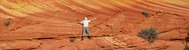
Hawksbill Crag (Whittaker Point) – Ozark Mountain, AR Deep within the Ozark Mountains, a short drive from the buffalo river lays Hawksbill; get to the trailhead is the toughest part since the entrance to the gravel road is not marked. To get there - take Hwy. 43 West from Harrison and continue through Ponca and the Boxley Valley. Head south on Hwy. 21 for 1.2 miles and turn right on gravel road called Cave Mountain Road (we never saw the sign). The dirt road will climb approximately 6 miles until you reach a tiny parking area on the right. The trail starts across from the parking lot. The hike started off with a long winding descent down the forest. After a fairly long stroll through the woods, we crossed over a small stream and were confronted with a 3 way junction. We took the trail to the right; it quickly brought us near the cliffs. Don’t give up at this point because you will soon see Hawksbill and it’s only a short hike away. Whitaker Point was featured in 2005 on the cover of the Rand McNally U.S. Road Atlas so this overlook is worth a look! We went in July; I am sure the scenery is much better in Fall/Winter. Tips: follow the trail markers; we got loss on our way back & bushwhacked a little before joining the main trail. Mark coordinate of your car will bring additional security and a sense of direction. Bring adequate water in summer. The ups and downs can be strenuous if you are not in the best shape. Distance: ~3 miles round trip Side Trips: The Glory Hole is a unique geological wonder/waterfalls deep in the Ozarks. The trail is in the Buffalo District of the Ozark National Forest off Highway 16, about 5 .7 miles east of Fallsville in Newton County, Arkansas. After passing a red barn on the left, go 0.5 mile & pull off opposite a house on the left. There is a steep jeep road you can drive down if you don't mind tear up the tires but I would park next to the road. On the day we visited, the creek leading up the waterfall was dry. The hike is one way out/in so there is little chance of getting lost. Nearby are 2 other noteworthy places to visit; these are 2 "must do" places in the Ozark - Roark Bluff (near Ponca) & Goat Trial (Hwy 43 North out of Ponca & Turn Right into Center Pt. Trailhead after 3.5miles). Goat Trail is quite a hike & a GPS is necessary in order not to get lost at the three way intersection approaching the bluff; however most likely you will have company so chances of missing the bluff is low..
Mountain Parks Petite Jean, Mt. Magazine & Queen Wilhelmina State Parks - near Little Rock, AR When visits to the Rockies were not possible due to bad weather, we headed to Arkansas and visited three mountain parks - Petite Jean, Mt. Magazine and Queen Wilhelmina State Park. The three parks are only hours apart and not far from Little Rock, Arkansas. Our 1st stop was Petite Jean State Park, it is Arkansas's first state park created in the 1920s. Other than the park scenic drives and the overlooks (including Stout’s Point), we hiked Cedar Falls and Bear Cave. Stout’s Point is a rocky bluff on the top of Petit Jean Mountain that offers a 180-degree panoramic view of the surrounding areas. This was also the gravesite for Petite Jean. The most well known hike in the park is probably the Cedar Falls trail. This is a short down (into the valley) hike that starts are the Mather Lodge and ends at a waterfall. What made this hike unique was the mist that coated everything surrounding the waterfall, and made everything sparkled in the sunshine. The branches were like crystal chandlers. This also made walking dangerous; we had to dodge icicles the size of bananas falling from the ledges above. Our next stop was the Bear Cave. This is an area of maze and narrows that can offer a lot of fun in scrambling and hide-&-seek. There is no true “cave” other than a hole in the rock that is the size of a living room. It was a fun place and reminded us of the “The Ledge” trail at Cuyahoga National Park. Our 3rd stop was Mt. Magazine (near Paris, AR) that boasts as having the highest peak in the State of Arkansas. We hiked the Southern section of the Bear Hollow and Eastern section of the North Rim Trails. The most memorable section of the hike was Dill Point along the North Rim Trail. This overlook offered a 180-degree view of the valley below and mountain in Oklahoma. Out last stop was the Queen Wilhelmina State Park near Mena, Arkansas. it is only about a hundred feet lower in elevation than Mt. Magazine (~2700 feet) so the entire mountaintop by the lodge offered expansive views of the surrounding areas and the Ouachita National Forest. We got up at 6am and took the Lover’s Leap trail to catch the sunrise. Bracing sub zero temperatures well below single digits we found ourselves jump for joy as dawn had broke and the sun “jumped” above the horizon. The sky in the opposite direction was a deep lavender but soon turned into mixture of yellow and orange. On our way back to the lodge, we got a few odd looks as if they were saying “are you nuts…its zero degree out!” Overall, we had a good time despite the brutally cold weather. The parks reminded us of Virginia’s Shenandoah and Ohio’s Cuyahoga National Park and Hocking Hills… The landscape in the winter is more desolate but the views are more wide open. There are also less people and cars that translate to fresher air and less noise. However, as with other popular destinations that are closer to the metropolitan areas, these parks can't escape the modern day graffiti of having people carve their initials into the rocks and trees. Nevertheless, we were glad to see there are big warning signs to deter this behavior... through education, perhaps people will learn to appreciate and protect their natural resources...so travelers like us will return. TIPS: don’t underestimate Arkansas winter, it can be dangerously cold in the wind and no flesh should be exposed when wind chill drops down to single digits. Camping here in the winter can be a good prep to see if you got what it takes to tackle bigger mountains. Distance: ~ 2-5 miles roundtrip (Mt. Magazine hikes are longer ~5 miles roundtrip)
|